The Ohio Trails Act formed this 40 mile hiking section of the Miami and Erie Canal Towpath Hiking Trails. Various forms of Ohio canal history such as canal locks, aqueducts, and a canal boat add to this section of the Ohio Buckeye Hiking Trails, which parallels State Route 66 from Delphos, Ohio, to Fort Loramie. The "Ohio Byway" road signs reference this area as having Miami and Erie Canal attractions.
Take a walk back into Ohio Canal history and view one of region's first engineering wonders with this Web site which contains 40 pages of attractions with over 80 photographs and maps.
Hiking distances for Miami and Erie Canal trails, are roughly:
Delphos to Spencerville, Ohio: 10 miles
Spencerville to St. Marys, Ohio: 14 miles
St. Marys to New Breman, Ohio: 9 miles
New Breman to Minster, Ohio: 4 miles
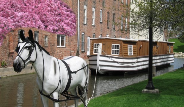
Minster to Ft. Loramie, Ohio: 3 milesWhen driving this Ohio Byway, consider alternatives to State Route 66 such as the Delphos Southworth Road and portions of route 66A. Saint Marys, Ohio, also has number of options to the Miami and Erie Canal hiking trails, including a canal boat on display. Lake Loramie State Park and Grand Lake St. Marys State Park each have a camp ground. Saint Marys has two motels.
For special needs viewers:
Each Web page has a "next" hyperlink after the page title and as the last entry on each page.
Below the "next" hyperlink on this page is the table of contents of the Web site.
Delphos Ohio Jennings Creek Aqueduct
Delphos Ohio Lock 24 N, at Stadium Park
Delphos Ohio Spillway and Lock 23 N at Third Street
Hiking Trails at Locks 18 N - 22 N
Miami and Erie Canal Lock 17 N
Hiking Spencerville, Ohio Trails at Locks 15 -16
Hiking trails at Canal Deep Cut Historical Park
Ohio Canal History - Boom Years
Current Construction on the Miami and Erie Canal
Hiking trails at Prairie Creek Aqueduct
Miami and Erie Canal Six Mile Creek Aqueduct
Miami and Erie Canal Hiking Trail at Bloody Bridge
Ohio Canal History - Canal Design
Hiking at Miami and Erie Canal Lock 14 N
Hiking trails at Forty Acre Pond
St. Marys Ohio hiking trails - RR Trestle & Tunnel
St. Marys Ohio History of the Hydraulic waterway
St. Marys Ohio historical Grist Mill
Miami and Erie Canal Lock 13 N
St. Marys Ohio Memorial Park and Canal Boat
Hiking Trails at the Grand Lake feeder canal junction
1860's house - Reflection of Ohio Canal History
Miami and Erie Canal feeder lake: Grand Lake St. Marys
St. Marys, Ohio Canal History at Bulkhead Lock
Hiking trails at Miami and Erie Canal Locks 3 N through 9 N
Historical Miami and Erie Canal Mile Marker 124
Historical Buildings at Lock 2 N
New Bremen, Ohio Lock 1 N and gravel towpath trail southward
Ohio feeder lake: Lake Loramie
Fort Loramie Ohio hiking trails at Loramie Creek Aqueduct
Fort Loramie, Ohio Canal History and St. Michael's Church
Viewable Miami and Erie Canal Map