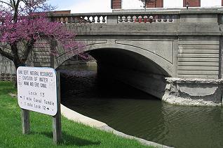
Saint Marys Ohio has three water ways that run within a city block of each other. The St. Marys River is the lowest of the three water levels and provide the natural drainage. The Miami and Erie Canal, which was constructed for transportation, and with the aid of two canal locks, lowered that waterway to an medium height. The Saint Marys Ohio hydraulic canal was a water way which split from the Miami and Erie Canal prior Lock 12 and 13 with the Hydraulic remaining at a high level. Industry used to water from the Hydraulic to power water wheels for factories with belt driven equipment prior to the expanded use of steam boilers or the use of electric motors.
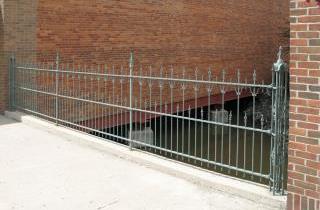
The rod iron fence on the north side of Spring St. in downtown St. Marys Ohio avails that the hydraulic still flows under the building foundations.
|
|
|
Saint Marys Ohio Canal History Attractions:
St. Marys Ohio hiking trails - RR Trestle & Tunnel
St. Marys Ohio History of the Hydraulic waterway
St. Marys Ohio historical Grist Mill
Miami and Erie Canal Lock 13 N
St. Marys Ohio Memorial Park and Canal Boat
Hiking Trails at the Grand Lake feeder canal junction
1860's house - Reflection of Ohio Canal History
Miami and Erie Canal feeder lake: Grand Lake St. Marys