OHIO BICYCLE TRAILS:
A BIKE TRAILS DIRECTORY
OHIO BICYCLE TRAILS:
A BIKE TRAILS DIRECTORY
Area Sensitive Map...
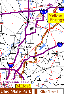
The 75 mile paved Little Miami Scenic Trail with gentle grades extends from Springfield, Ohio to eastern Cincinnati, much along the Little Miami River. It is a major trail within the Miami Valley Bike Trail system which consists of hundreds of miles of interconnecting trails.
The north end of the Little Miami Scenic Trail, is located at the south west corner of Springfield, Ohio. off I-70 using the SR-72 exit, going north a block or so to W. Leffels Lane, and head west to the trail. W. Leffels Ln. and SR-72 area has restaurants, however we are not aware of any parking lots at the trail head itself. Just west of this trailhead is Springfield-Xenia Rd. which parallels the trail, and is a short cut to US-68 going to Yellow Springs. (Refer to the area sensitive map which contains a dozen of individual maps of this area.) A large parking lot is located in Yellow Springs, Ohio, home of Antioch College, just east of Dayton, Ohio. When coming into Town on Route 68, the bicycle trail crosses the road a few feet north of a nationally know "sub sandwich" restaurant. The large municipal parking lot to use with the bicycle trail is a quarter block to the north and a quarter block to the west which is just off of Dayton Yellow Springs Rd. The parking lot is next to the bike trail on the north side of this street.
The south end of the Ohio bicycle trail starts up on the side of a hill on the west side of Milford, Ohio just west of State Route 126, immediately west of the Little Miami River. On a normal day, the parking lot next to the bike trail appears to be able to handle a moderate number of cars.
The bicycling trail goes directly through the Cities of Xenia, and Loveland, adjoining their city parks which have facilities. The village Morrow is a nice a nice place to take such a break. The bike trail also brushes Waynesville, Corwin, and Kingsmills (an area near motels).
The Miami Valley Bike Trail system consists of a trails spidering out from Xenia Ohio and trails spidering out from Dayton Ohio with these two cities connected by the "Creekside Trail".
The cites below are interconnected by this trail system:
Urbana, Buck Creek State Park, Springfield, Yellow Springs, Xenia, Springvalley Wildlife Area, Fort Ancient State Memorial, Morrow, Loveland, Milford, Avoca Park.
Xenia, Wilberforce, Cedarville,
Xenia, South Charleston, Jameston
Xenia, Dayton, Riverside
Dayton, Riverside, Fairborn
Dayton, Kettering, Centerville's Iron Horse Park
Dayton, Trotwood, Brookville
Troy, Tipp City, Huber Heights, Dayton, West Carrollton, Miamisburg, Franklin,
Outside Links: |
Exit pop up browser to return to this site. |
| Xenia Station | |
| Great Web Site: Little Miami Scenic Trail or Complete Trail System Map | |
| Over 700 miles of Ohio Trails (.pdf) | |
Home / Grand Rapids(Toledo Area) / Fremont / Elyria / Brecksville(Cleveland Area) / Bowling Green /Celina / Massillon /New Bremen / Massillon / Lisbon /Strouthers(Youngstown Area) / Mt. Vernon / Newark / Athens / Dayton-Xenia / Xenia-Ciderville / Springfield-Milford(Cincinnati Area)
 Our
Adventure
Our
Adventure