 THE BICYCLE TRIP
YELLOW SPRINGS, OHIO
OUR ONE DAY ADVENTURE |
PREPARATION
Our 61 mile Little Miami River bicycling trip originated after dad asked, "Son, what would you like to do special with your dad this year." I was then committed. With very little conditioning, out side of jogging twice a week, our father-son week-end was rapidly approaching. On a prior year when we rode the Little Miami trail when it was only 22 miles long. My son blew out a tire on a curb just after lunch within the south east part of Loveland, Ohio. Fortunately, a store with bicycle supplies was just down the street from "Hamburger Alley". Since then, after inspecting, lubricating, and adjusting our bikes, we always carry an air pump, inner tubes, wrenches, and screwdrivers with us. I asked my brother from Cincinnati, to ride with us, and we traveled from north-west Ohio.
THE BICYCLE TRIP
YELLOW SPRINGS, OHIO
Our families met at 10:15 AM, in the Yellow Springs Municipal Parking Lot which was heavily patrolled by the Police simply because it is the only way in and out from their office. After using the municipal building "facilities", our adored loved ones took both cars, later dropping one of the cars off as a predetermined side street in Milford, Ohio. With three bikes, lots of fluids, and a few repair supplies, my son, brother, and I were off. After passing the Sandwich Shop, and an apparent bicycle rental shop located in a railroad caboose, we passed Antioc College to the one side and a forest sloping downward on the other side. After the bike trail crossed a large girder railroad bridge over looking a scenic river, we continued our way to Xenia.
XENIA, OHIO
At the north end of the City of Xenia, we ate at a fast food restaurant, which
was adjacent to the trail. As we traveled the bicycling trail through Xenia, it went into
the former parking lane of the roadway within the downtown area. The independent bicycle
trail re-emerged going through a park on the southwest section of town. We drew cautious
as we crossed one or two busy streets. It was back into the country side as we caught a
glimpse of route 42 for a number of miles before heading more southward. As we crossed the
valleys traveling 15-18 miles per hour, we enjoyed viewing the fields of grain, and farm
homesteads resting on the slopes of the hillsides. 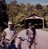
While pedaling near Waynesville and Caesar Creek State Park, a covered bridge came into view just west of the trial. A good excuse to take a 5 minute break.
After getting back on the trail, and a few more miles down the "road," I found out the tables had turned, I call out to my son, "Slow Up", about 15 mph was my maximum. I thought back to the time only a year earlier, while on a 100 mile trip with a strong wind to our back, I repeatedly told my 14 year old son, "we got to pick up the pace". The bike trail took us from the ridge into a deep very wide gorge as the immense spans of the I-71 bridge towered in the sky. One can only imagine the engineering that went in such a structure. As we past by, my brother remarked no wonder US route 42 was the way to Columbus for so many years.
MORROW, OHIO
During the remainder of the trip, the bicycling trail spans near the banks of the Scenic Little Miami River most of it's distance. As we pass a canoe livery or two, things become more familiar to the bike ride my family made several years earlier. I kept an eye out at the tall sycamore trees on the west side of the river. We turned off the trail onto a bridge. It was the wrong one. After continuing down the trail some more, we again left the trail, crossing over the river and to the right.
WE FOUND IT! The campgrounds where I and the kids had camped on that earlier trip. As we believe it to be, Morgan's Riverside Campground, 6146 Gilmore Rd., Morrow Ohio (513) 899-2166 / (800) WE CANOE. A sign was plainly posted prohibiting non-campers from going back into the camping area. The concession stand was open, and we took a liquid refreshment break, along with a snack. I then popped the question to the employee behind the counter, " IS THE BIG TREE STILL BACK THERE?" "THERE IS LOTS OF BIG TREES BACK THERE", he replied. The employee then gave us permission to go back and look.
 THERE
IT WAS, appearing over six feet wide at it's base, it was the BIGGEST tree I have seen
east of the rocky mountains. Only speculation could say if this tree towered over the land
100 or 200 years, prior to the other 200 year old trees first taking root in this river
bottom land. This tree like many in the area, appear to have resisted the brutal lightning
strikes over the years.
THERE
IT WAS, appearing over six feet wide at it's base, it was the BIGGEST tree I have seen
east of the rocky mountains. Only speculation could say if this tree towered over the land
100 or 200 years, prior to the other 200 year old trees first taking root in this river
bottom land. This tree like many in the area, appear to have resisted the brutal lightning
strikes over the years.
We then returned to the entrance of the campgrounds, and enjoyed viewing another tree in
which one could see through it in numerous places. It was full of holes and the hollow
center appeared to have been burned out at one time. The tree continued to display it's
healthy leaves, and branches.
After getting back on the bicycling trail, I work out a small cramp, as we continue onto
"Morrow", the small town which at one time had been the northern end of the
trail. By the time we got there, it was 3 PM, and I was the only one that was hungry. We
stopped in at a little shop immediately to the north of the trail, on the west end of the
village. I enjoyed the big home town welcome, a fish sandwich, chips, and slaw for about
$3.00. My Son then took me up on my offer for an ice cream cone. He had many flavors to
choose from.
We stopped at the public restrooms next to the bicycling trail prior to heading west out
of town toward South Lebanon. The abandon looking multi-story structure at Kings Mills has
a placard beside it explaining it role during WW2. The trees shade the trail much of the
time as we travel mile after mile, with steep sides of the hills on one side of the
bicycling trail, and the Little Miami river on the other.
LOVELAND, OHIO
We finally come to City of Loveland, Ohio. At the north edge, we pass the city park drinking fountain, and restrooms. We also passed the ice cream and other shops, prior to crossing a set of RR tracks. We viewed the rails which lead from the current RR track toward the old RR bed the bicycling trail was now on. We travel out of town, and under the I-275 Cincinnati outer belt. Again, I ask my son to slow up.
MILFORD, OHIO
The terrain still appears rural, even thou it's abutting urban sprawl. After passing some very tall towers, we are there, at the trail's end. Dad was about ready to collapse, and son perky as ever. We then left the trail, and crossed the river to predetermined location within Milford where our wives had left the car. Weary, but well satisfied, we drove to my brother's house in time for supper.
Home / Grand Rapids(Toledo Area) / Fremont / Elyria / Brecksville(Cleveland Area) / Bowling Green /Celina / Massillon /New Bremen / Massillon / Lisbon /Strouthers(Youngstown Area) / Mt. Vernon / Newark / Athens / Dayton-Xenia / Xenia-Ciderville / Springfield-Milford(Cincinnati Area)