 OHIO BICYCLE TRAILS:
A BIKE TRAILS DIRECTORY
OHIO BICYCLE TRAILS:
A BIKE TRAILS DIRECTORY
Newark Ohio
Licking County Trails:
Thomas J. Evans Trail
Panhandle Trail
Black Hand Gorge Trail
The
Thomas J. Evans Trail is a 14.3 mile paved bicycle
trail running along Raccoon Creek northwest of Newark up to
Johnstown. .
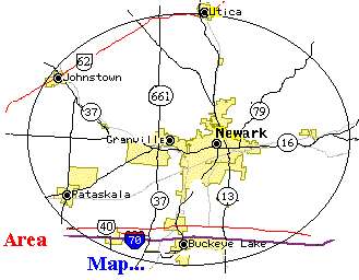
The Panhandle Trail runs 10 miles from the E. Main & Morris St. in Newark, past the multi-story Longabarger Basket Office Building, to Felumlee Rd. (Parking near Hanover may be more appealling than on Morris St. During our visit, it appeared stones had been thrown onto the paved parking lot at Morris St.) About midpoint in the bike trail is S. Main in Hanover Ohio, aka, Licking Valley Rd., aka, 668. Taking 668 south leads to the Black Hand Gorge Trail. Road names to make this mile or so jog include going briefly on Marne Rd. and crossing S.R.16 on Brownsville Rd. with the trail being on the south side of the Licking River just off Brushy Fork Rd. The bicycle trail extends east to the beautiful Black Hand Gorge Nature Preserve located southeast of Hanover Ohio. (The Preserve is listed on many Ohio road maps.)
Outside Links: |
Exit pop up browser to return to this site. |
| Ohio Bikeways Review of: Blackhand Gorge Review or Panhandle Trail Review | |
| Detailed Trail Map | |
| Video of Blackhand Gorge Trail | |
| Over 700 Miles of Ohio Trails | |
Home / Grand Rapids(Toledo Area) / Fremont / Elyria / Brecksville(Cleveland Area) / Bowling Green /Celina / Massillon /New Bremen / Massillon / Lisbon /Strouthers(Youngstown Area) / Mt. Vernon / Newark / Athens / Dayton-Xenia / Xenia-Ciderville / Springfield-Milford(Cincinnati Area)