OHIO BICYCLE TRAILS:
A BIKE TRAILS DIRECTORY

CREEKSIDE TRAIL


The Miami Valley Bike Trail system consists of hundreds of miles of various bike trails spidering out from the Xenia Ohio hub and from the Dayton Ohio hub.  These two hubs are connected to one another by the "Creekside Trail". 

Creekside Bike Trail extends seventeen miles from East Wood Park off Springfield St in Dayton Ohio, to Xenia Station.   Creekside Trail is  on a former rail road bed near State Route 35 through the Dayton area community of Beavercreek and includes the original railway bridges.   Xenia Station has a huge parking lot and is located off S.R. 380 a quarter of a city block south of where S.R. 380 splits from U.S. 68 in the southern portion of the City of Xenia.

The cites below are interconnected by the Miami Valley Bike Trail system:

Urbana, Buck Creek State Park, Springfield, Yellow Springs, Xenia, Springvalley Wildlife Area, Fort Ancient State Memorial, Morrow, Loveland, Milford, Avoca Park.

Xenia, Wilberforce, Cedarville,

Xenia, South Charleston, Jameston

Xenia, Dayton, Riverside

Dayton, Riverside, Fairborn

Dayton, Kettering, Centerville's Iron Horse Park

Dayton, Trotwood, Brookville

Troy, Tipp City, Huber Heights, Dayton, West Carrollton, Miamisburg, Franklin,

About this web site...

Outside Links:

Exit pop up browser to return to this site.
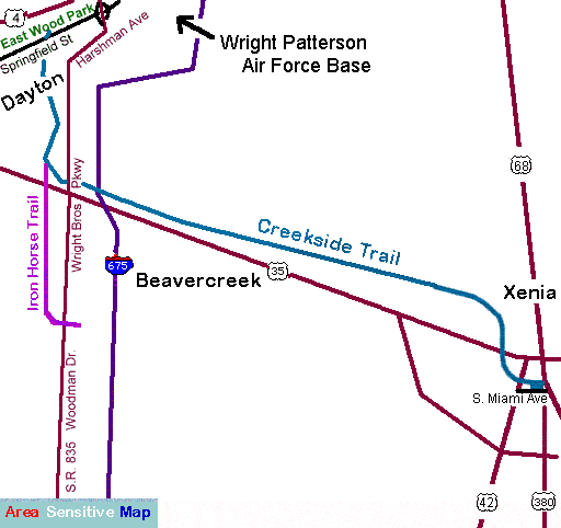
Xenia Station
Great Web Site:  Creekside Trail or Complete Trail System Map
Over 700 miles of Ohio Trails (.pdf)       


Home / Grand Rapids(Toledo Area) / Fremont / Elyria / Brecksville(Cleveland Area)  / Bowling Green /Celina / Massillon /New Bremen / Massillon / Lisbon /Strouthers(Youngstown Area) / Mt. Vernon / Newark Athens / Dayton-Xenia / Xenia-Ciderville / Springfield-Milford(Cincinnati Area)