| Home | Grand Lake History | Canal History | Celina to Wright State Campus | Wright State Campus to St. Marys | Lake Tour Map |
 Celina to
Wright State
Celina to
Wright State
A Slide Show Tour
Disclaimer
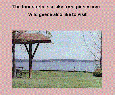
This tour starts as the south end of West Bank Rd. within the Grand Lake St. Marys "West Bank" state park just south of Celina, Ohio.
The park has beautiful view of the lake along a shaded shore line. The picnic section of the park is made up of parking lots, a modest restroom and picnic tables.
Our tour heads north passing a restroom with running water which is located at the boat ramp next to the bay. After passing the dam, one of Celina's finer restaurants, and tour boat, one comes upon the light house. The light house is part of Celina city park which has public access along the shore line up to Lake Shore Drive. Continuing on Lake Shore Drive leads northeast to Market St. Once at up to Market St., more lake view restaurants are available. In addition to the chain restaurants, there is a independent lake side restaurant people enjoy. On the south side of Market St. heading east is a good side walk up to about 2 blocks from S.R.709 where there is a wider than normal berm on the road. A couple more nationally known restaurants have a lake view at S.R.703, including the one with pizza which have their own docks for boating guests. S.R.703 bike lane which is roughly 5 feet wide, and extends along side this highway which is fast pace at times. After passing lakeside neighborhoods, the Wright State Campus comes into view, a note worthy place to view the lake.
The "West Bank Rd. of the State Park to
Wright State shore line is about 4 1/2 miles.
Wright State through the State Park to St. Marys Memorial Park is about 11 1/2
miles.
The "Lake and Canal
Tour " is just about 16 miles going the one
direction.
| Outside Linksa | Canal Attractions | St. Marys Area Attractions | Canal Boat Rides |